The Florida Fish and Wildlife Conservation Commission (FWC) released its newest report on the status of seagrass beds in Florida's waterways. This is the second edition of the report, gathering data on 23 regional "chapters," and is the result of monitoring work done by over 40 scientists from agencies statewide. Overall, the report estimates that the state has approximately 2.5 million acres in its estuaries and other water bodies, the most of any state in the continental U.S. Approximately 65% of this coverage is located in the southern portion of the state, with another 25% in the Big Bend region.
This data is collected largely through the Braun-Blanquet method, allowing for scientists to asses both abundance and species composition along their transects. In narrower regions, such as the Indian River Lagoon (IRL), these transects are often established across beds and are monitored on a routine basis. Other water quality parameters (e.g. temperature, salinity, chlorophyll, Secchi depth) are also collected at many sites during sampling. Additionally, some sites are mapped by aerial imagery (either satellite or aircraft) or SONAR. State agencies are often tasked with monitoring in order to better understand what conditions may be causing declines in seagrass coverage.
This data is collected largely through the Braun-Blanquet method, allowing for scientists to asses both abundance and species composition along their transects. In narrower regions, such as the Indian River Lagoon (IRL), these transects are often established across beds and are monitored on a routine basis. Other water quality parameters (e.g. temperature, salinity, chlorophyll, Secchi depth) are also collected at many sites during sampling. Additionally, some sites are mapped by aerial imagery (either satellite or aircraft) or SONAR. State agencies are often tasked with monitoring in order to better understand what conditions may be causing declines in seagrass coverage.
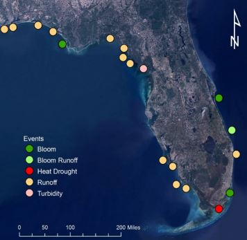
Major causes of seagrass loss throughout Florida since 2012 (from FWC report)
Most seagrass loss in Florida has historically been because of light limitation, either from shading by sediments or phytoplankton, and human activities are commonly at fault. Comparing coverage between previous years, most of the loss was attributed to runoff, particularly along the Panhandle and Big Bend coasts where wetter than average weather has led to elevated sediment loading. Other areas experienced loss due to various algae blooms. The northern IRL, for example, was reported to have actually gained about 15% of the seagrass previously lost from the 2011 "Superbloom" between 2011 and 2013; however, the estuary is now experiencing an intense "brown tide" bloom with unknown consequences for recent seagrass coverage.
These reports are important for state and national agencies to better understand and set water quality guidelines for these estuaries. Additionally, they act as a data source for stakeholders, permitting agencies, and other scientists. Given the reliance of the state's economy on seagrass ecosystems, monitoring of its coverage should be a priority. Funding for the Seagrass Integrated Mapping and Monitoring (SIMM) program is only guaranteed through 2017.
These reports are important for state and national agencies to better understand and set water quality guidelines for these estuaries. Additionally, they act as a data source for stakeholders, permitting agencies, and other scientists. Given the reliance of the state's economy on seagrass ecosystems, monitoring of its coverage should be a priority. Funding for the Seagrass Integrated Mapping and Monitoring (SIMM) program is only guaranteed through 2017.
 RSS Feed
